the assumption of responsibility for the welfare of the world
|
STEWARDSHIP the assumption of responsibility for the welfare of the world |
|
SITE MAP
|
REFERENCE BASE
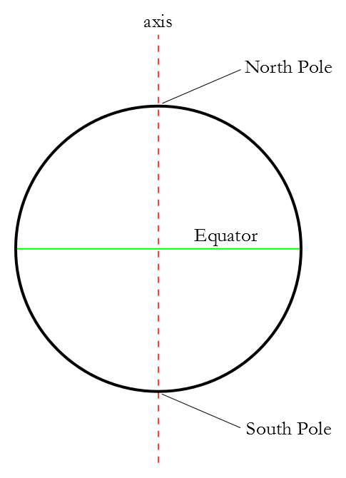
Latitude is a measure of how far north or south a point on the surface of the Earth is. Lines of latitude thus run around the Earth from east to west. The Earth is roughly a sphere, and it rotates on an axis. The points where that axis intersect the sphere, on opposite sides, are important fixed reference points; we call them the North Pole and the South Pole. Halfway between them is the Equator; the Equator is a line formed by all those points around the surface of the sphere that are halfway between the North and South Poles. The location of the poles and the Equator are thus fixed simply by the shape of the Earth, and the fact that it rotates.
Latitude is measured in degrees, and there are 360 degrees in a circle. The Equator is used as the point of reference, so it becomes 0° latitude. The North Pole and South Pole are separated from each other by half the circumference of a circle, or 180 degrees, and each is thus 90 degrees from the Equator. As latitude is a measure of how far north or south a point is, the North Pole is 90° north latitude (or simply 90° N), and the South Pole is 90° south latitude (or 90° S). Latitude has a significant impact on climate, because the Earth is round, and the suns rays do not strike the Earth uniformly at the same angle. Consider the daily temperature cycle: the warmest time of day is roughly in the middle of the day, while early morning and late evening are much cooler, and the night colder still. This is true even though, of course, the Earth is not moving significantly closer to or further from the sun over the course of the day; parts of the Earth are moving closer or further away as the Earth rotates, but this change is quite insignificant given how far away the sun is to begin with. Thus, we can reason that the angle of the sun makes a difference in how warm a point on the Earths surface is. When the sun is directly overhead, the Earth is nearly at its warmest; when the sun is at a low angle, out on the horizon, the Earth is cooler. Depending on longitude how far east or west a location is the warmest part of the day will come earlier or later than other parts of the Earth.
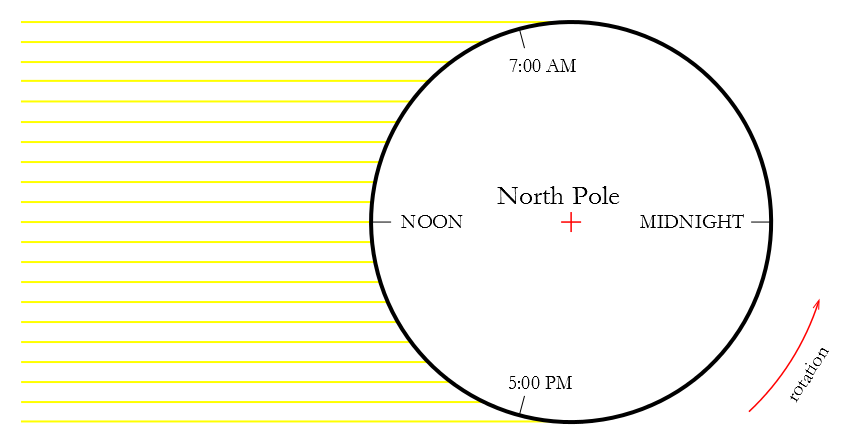
As can be seen in this diagram of the Earth from above, the parallel lines of the suns radiation strike the Earth at different angles, depending on time of day. At midnight, a location receives no direct sunlight, and is cold. At 7:00 AM, the Earth is warming up slightly. At noon, the sun is directly overhead, and the Earth is nearing its warmest. By 5:00 PM, the Earth is cooling off. This variation in the angle of sunlight happens because the Earth is round. But the Earth is not round just from east to west, of course. It is also round from north to south. We should expect a similar effect for latitude; we should get more warmth when the sun is directly over our latitude, and less when it is at a lower angle. And this is, in fact, what happens, but instead of changing over the course of the day, it changes over the course of the year, and is responsible for the seasons. There is a reason that most globes, or models of the Earth, have the Earth mounted at an odd angle, so that the axis of the globe isnt oriented straight up and down, but tilted. Thats because the axis of the Earth itself is tilted. The Earth goes around the sun in an orbit, and that orbit defines a plane. If the Earths axis were perpendicular to the plane of orbit, we would not have our current seasons; each latitude would get sunlight at the same angle every day, varying with the time of day, but not varying from, say, noon on one day to noon on a day two months later. The Earths axis is in fact tilted away from that perpendicular by 23.4 degrees.
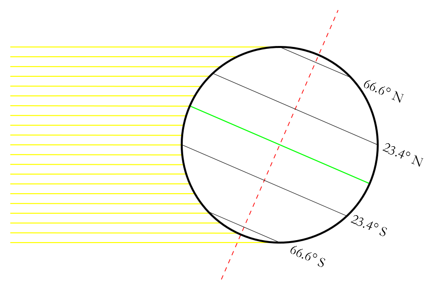
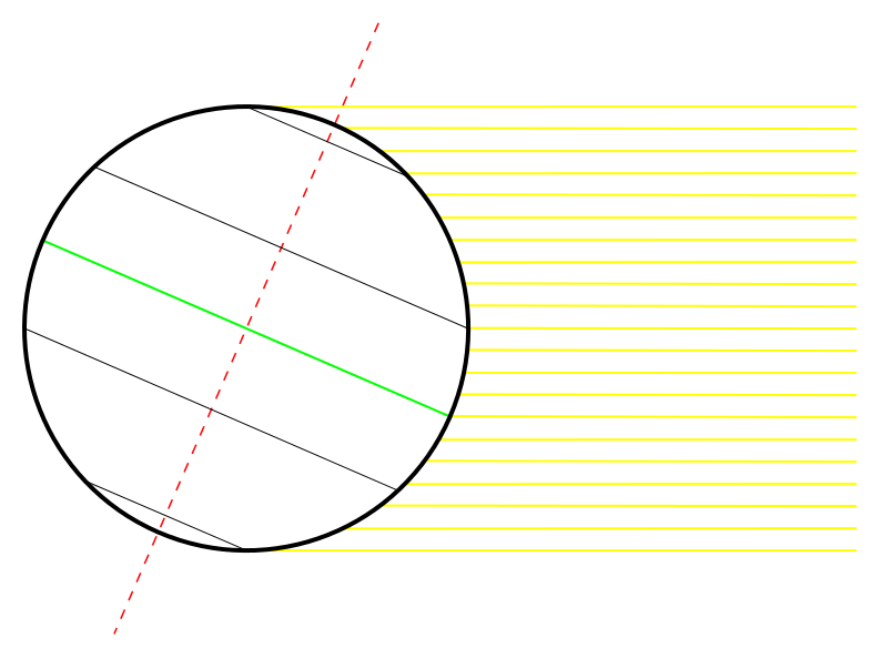
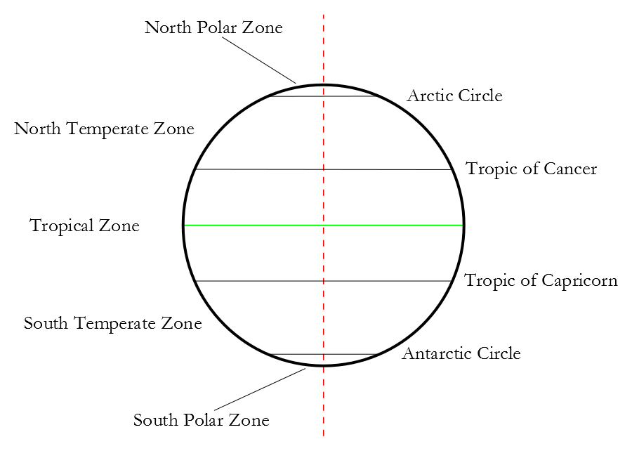
The diagram above depicts a particular day: the winter solstice in the northern hemisphere. The southern hemisphere is oriented towards the sun. Because of the axial tilt, the latitude directly facing the sun is not the Equator, and the points dividing the light and dark sides of the Earth are not the poles. Those latitudes are shifted 23.4°, so that the latitude facing the sun is 23.4° S, and the latitudes dividing the light and dark sides of Earth are 90° 23.4°, or 66.6° (both north and south). In fact, if you imagine the Earth rotating on its axis, you can see that on the winter solstice, the entire area north of 66.6° N receives no sunlight at all, through an entire rotation, while the entire area south of 66.6° S is never dark during that same rotation. As the Earth orbits the sun, the tilt does not maintain a fixed orientation towards the sun. Rather, it maintains a fixed orientation in absolute space (of the solar system), so that as it orbits, the angle with the sun changes. Six months after the winter solstice, the northern hemisphere is tilted towards the sun.
And halfway in between, the axis tilts perpendicular to the suns rays. The sun is directly over the Equator. These fixed latitudes divide the world into five latitudinal climatic zones. North of the Arctic Circle, and south of the Antarctic Circle, are the polar zones. The polar zones receive the least sunlight, and every latitude in the polar zones has at least one full day without sunlight a year. Between the Tropic of Cancer and the Tropic of Capricorn is the Tropical Zone. Every latitude in the tropics has at least one day a year when the sun is directly overhead, and all but the Tropics of Cancer and Capricorn themselves have two; for the Equator, those two days are the equinoxes, so called because night (Latin NOX) and day are equal. Between the Tropic of Cancer and the Arctic Circle, and between the Tropic of Capricorn and the Antarctic Circle, are the temperate zones. These descriptors polar, temperate, and tropical give a rough idea of climate, because they give a rough idea of the amount of sunlight the zones receive. (The name temperate just means moderate, as a description of the zones climate. The polar zones were once called frigid, while the tropical zone was once called torrid.)
The climate effect of the variations in sunlight does not, of course, change drastically at the dividing lines, even though the dividing lines themselves have precise definitions. The climate just north of the Tropic of Cancer is about the same as the climate just south of the line, just slightly cooler; and the Earths climate system is determined by more than latitude, in any case, so it is easily possible and in fact quite common for selected locations to have warmer climates than other locations close to the Equator, or colder climates than other locations closer to the poles.
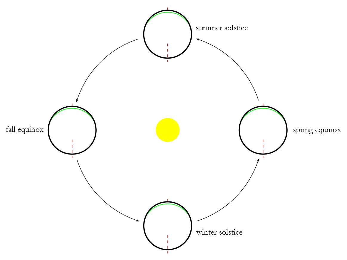
This diagram shows the Earths orbit from above. The Earth orbits counterclockwise around the sun, with the Earth maintaining a fixed orientation in space, rather than toward the sun. The seasons are determined by the position of the Earth in orbit, with summer in each hemisphere coming when the hemisphere is oriented towards the sun, and winter coming when it is oriented away. There are four calendar days each year determined by the position of the Earth in orbit. In order, they are, for the northern hemisphere: the winter solstice (December), when the sun is over the Tropic of Capricorn, the spring equinox (March), when the sun is over the Equator, the summer solstice (June), when the sun is over the Tropic of Cancer, and the fall equinox (September), when the sun is over the Equator again. The exact day varies year by year, but falls in the range from the 19th to the 24th. The southern hemisphere dates are different by six months: winter solstice in June, spring equinox in September, etc. (The equinoxes are frequently named in Latin: vernal equinox (spring); autumnal equinox (fall).)
It is often asserted, supported by some technical usage, that the solstices and equinoxes are the official beginnings of the seasons winter begins on the winter solstice, spring on the spring equinox, summer on the summer solstice, and fall on the fall equinox. But the seasonal names exist primarily to describe a certain human experience, and to a lesser extent natural effects, that do not begin or end neatly on a schedule defined by exact dates corresponding to planetary movement. The period between the summer solstice and the fall equinox wont usually be the warmest three-month period of the year. Snow and freezing temperatures are not confined to the period between the winter solstice and the spring equinox. There is no reason, for that matter, to divide the year neatly into four equal periods, and many cultures closer to the Equator, where the annual temperature range is smaller, tend to divide the year instead into two seasons, dry and rainy.
© O.T. FORD |
THE STEWARDSHIP Home of the Stewardship Project and O.T. Ford |